Recreation,tourist,travel,Washington,Mt. St. Helens,Mt. Rainier,forest,fishing ,hunting,camping,hiking,steelhead,salmon,trout,deer,elk,bear,mushroom,logging,White Pass Highway Shopper Newspaper,environment,volcano,U. S. Forest Service,Gifford Pinchot National Forest,Wenatchee National Forest,tourism ,events ,Packwood,Morton,Randle,Naches
Weekly current recreation report covering all outdoor activities including fishing, hunting, hiking, camping, skiing, mushroom, berry and firewood gathering around Mt. St. Helens, Mt. Rainier and Mt. Adams in the Cascade Range forests along the White Pass Highway in southwest Washington State.
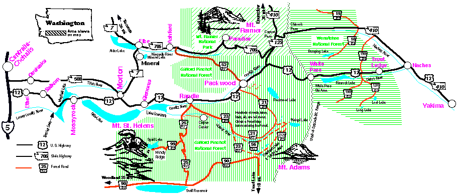
See a map showing our area here:

Important Note: This page is updated weekly. If this page produced by your browser is out of date, give your menu command "Reload Source" or equivalent. In seconds, your browser will then come to my server and get the current version. Sadly, some browsers refuse to update on command. If yours won't, use another browser. Thanks!
E-Mail: news@highwayshopper.com Please phone or snailmail anything urgent or especially important.
Recreation Report from Shopper
for October 8, 2008Submitted by Joe Kulig.
Here are the current Fishing Prospects as predicted by the Washington Department of Fish and Wildlife
Here are the Washington State Spring Reports of Fish Stocked, Updated Weekly
Here are the Washington State Spring Plans for Fish to be Stocked in this year
See the guide listing resorts, restaurants, motels and businesses serving every tourist need in this beautiful recreational area!
Publisher Dave Bunting displays his fish caught while on vacation in Minnesota. Together with his brother and fishing buddies, the four of them lined in 22 fish for the day. Dave caught 7 fish using a 24 inch twig with 15 feet of lead tied onto its end.
Photo taken 7/3/07
Recent Earthquake Activity
Morton
On Monday, Sept. 08, 2008 at 07:28 am there was a micro-earthquake of magnitude 1.5 at 10.2 miles deep, 5 mile S (178°) from Morton, at 46.483°N and 122.276°W.
Naches
On Sunday, August, 24 at 12:49 am there was a micro-earthquake of magnitude 1.6 at 4.2 miles deep, 7 miles W (275°) from Naches, at 46.737°N and 120.848°W.
On Wednesday, August 20 at 2:26 pm there was a micro-earthquake of magnitude 2.0 at 0.6 miles deep, 20 miles W (259°) from Naches, at 46.675°N and 121.105°W.
On Tuesday, August 19 at 12:14 pm there was a micro-earthquake of magnitude 2.7 at 0.4 miles deep, 4 miles NNE (13°) from Yakima, at 46.649°N and 120.513°W.
Ashford
On Saturday, August 23 at 2:05 pm there was a micro-earthquake of magnitude 2.6 at 4.3 miles deep, 8 mile N (357°) from Ashford, at 46.867°N and 122.028°W.
For information on recent earthquakes in Washington State go to:
Quick clicks to our various areas:
Mountain Highways and Pass Report
Packwood-Morton-Mossyrock-Salkum-Ethel Area
Mt. St. Helens
Mt. Rainier National Park
Fishing Westside & Eastside
Naches Area
General Information for All Areas including weather forecasts, El Niño reports, pollen forecasts, etc.
Elsewhere in Washington
Bristol Bay Sockeye Run
Lynx Hair Controversy
Bear Reports Up; WDFW Offers Safety Tips
With the arrival of warmer weather, sightings of black bears are on the rise and the Washington Department of Fish and Wildlife (WDFW) is reminding citizens that human actions are the key to avoiding trouble with a bruin.
"Don't feed the bears it's been said many times before, but that's still the most important advice we can offer said Capt. Bill Hebner, who heads WDFW's regional enforcement activity in northern Puget Sound. "Most bear problems begin with people feeding them, either intentionally or unintentionally.
"Pet food, birdfeeders and unsecured garbage containers all can attract hungry bears looking for an easy meal. And people who deliberately feed bears place themselves, their neighbors and the bears in danger.
"Problems arise when bears begin to associate people with food and lose their natural fear of humans. Each year, bear reports spike as the weather warms and bears begin to move in search of food. Possibly because of cold spring weather, calls about bears started slowly this year, but in recent weeks, the bears seem to be making up for lost time.
"Right now, the regional office here in Mill Creek is getting about a dozen calls a day from people concerned about bears on their property, raiding dumpsters and knocking down birdfeeders.
"By nature, black bears are afraid of humans, and will almost always go out of their way to avoid contact with them. Only a handful of bear attacks on humans have been recorded in state history. But once a bear associates people with food, the situation can become dangerous for both human and animal. Public safety is our first priority in managing potentially dangerous wildlife. For that reason, bears that have lost their fear of humans are euthanized. That's a shame, because bears often wind up paying the price for human carelessness. Human encounters with bears tend to subside by mid-summer, when berries and other natural foods become available.
"Until then, take a few simple precautions:
*Never intentionally feed bears or other wild animals.
*Keep garbage cans in a garage or another secure area until collection day.
*Remove pet food from areas accessible to wildlife.
*Thoroughly clean barbecue grills after each use.
*Take down birdfeeders until later in summer.
*When camping, keep a clean campsite by thoroughly cleaning all cooking utensils after use and sealing uneaten food in airtight containers stored in bear-proof canisters away from sleeping areas.
*In the event of an actual encounter with a bear, WDFW offers the following advice -
*Don't run.
*Pick up small children
*Stand tall, wave your arms above your head and shout.
*Do not approach the animal and be sure to leave it an escape route.
*Try to get upwind of the bear so that it can identify you as a human and leave the area.
*WDFW encourages those who have a dangerous encounter with wildlife to call the Wildlife Hotline at 1-800-477-6224. More information on living with black bears is available on WDFW's website at http://wdfw.wa.gov/wlm/game/blkbear/blkbear.htm.
RECREATIONAL SAFETY TIPS DURING
HUNTING SEASON
A variety of user groups, such as hunters, hikers and anglers, often share the outdoors throughout the year in Washington. The Washington Department of Fish and Wildlife offers the following advice to anyone recreating outdoors during hunting seasons:
Wear brightly colored clothing: Make yourself visible by wearing bright colors, such as blaze orange. Avoid wearing earth-tones.
Make noise: Alert hunters to your presence by talking, singing or whistling.
Make your presence known: If you hear someone shooting, let the hunters know you are in the area by raising your voice.
Be aware of hunting seasons: Hunting seasons occur in Washington throughout the year, except June and July. For more information on big-game hunting seasons, visit WDFW’s website at http://wdfw.wa.gov/wlm/game/hunter/hunter.htm.
Know your target: Hunters are trained and expected to confirm their target before firing.
Review full Washington State Hunting Seasons and Regulations:
http://wdfw.wa.gov/wlm/game/seasons.htm
Mountain Highways and Pass Report
Skate Creek Road #52; Elk Pass Road #25; Trout Lake #23; Cayuse Pass Highway #12; Chinook Pass Highway #410 and Stevens Canyon Road are all open. State Highway #123, will be subject to 20 min delays Monday through Friday daylight hours. Chinook Pass highway 410 is restricted to one lane alternating traffic at MP 73 for a short distance five miles east of the summit.
Road to Mount St. Helens Windy Ridge via Forest Road #99 from Randle is closed to all traffic at Bear Meadows including hikers and bikers. They can access the NE side via the Boundary Trail between Bear Meadows and Norway Pass. Vehicles without trailers will be allowed as far as Bear Meadows. Road repairs are about to begin, with a summer 2009 re-opening.
Packwood-Morton-Mossyrock-Salkum-Ethel Area:
Cowlitz Valley Ranger District,
Forest Roads
Packwood, Randle Area
#1260 Rd. Packwood Lk: open.
#1270 Rd. Backbone Ridge; Access over Jody’s bridge has been declared unsafe due to flood damaged, therefore a mandatory closure in affect to all use including foot traffic. Many citations costing $125 per person have being issued to people hiking across the bridge.
#20 Rd. Smith Ck. - open
#21 Rd. Johnson Crk: open.
#2130Rd.Deception -impassable
#2150Rd.Sno-grassFlats- open.
#23 Rd. Randle-TroutLk. Open; Slump in Rd. at MP 38.6.
#2304 Rd. Pompey Peak T.H.
Washout at 5.6 mile marker.
#2324 Rd. Sunrise - open.
#2329 Rd. High Lakes: open.
#2329.022 Rd. Chain of Lakes 8/15, closed to motorized use.
#25 Rd. Elk Pass 08/15, open.
Be alert for logging traffic. Drivers and motorcycle riders should use caution as some road areas may have settled; and rocks and other debris may be on the road bed. Four miles south of Randle, a bridge project will enable coho salmon to access additional habitat in Woods Creek. A temporary bi-pass bridge is in place with only minor delays.
#26 Rd. Quartz Creek- Closed to all traffic including hikers south of Ryan Lake. Repairs to begin.
#28 Rd. Pinto 8/29, open.
#2801 Rd. S. Cispus open.
#29 Rd. McCoy Creek open.
#2904 Rd. Lambert Sdl, open.
#44 Rd. Carlton Creek, rough.
#45 Rd. Cortright Creek 8/06 Open high clearance vehicles. #4510 Rd. Soda Springs 8/06 Open high clearance vehicles.
#46 Rd. Lava Creek 8/06 Open high clearance vehicles.
#4610 Rd. Purcell Creek 8/06 Open high clearance vehicles.
#4612 Rd. Bluff Lake- 8/06 Open high clearance vehicles.
#47 Rd. Willame; Randle End: Gated closed at MP 4; washed-out East Fork culvert.
#47 Rd. Willame Packwood End: Reported to be open through Willame Creek Pass to junction Silver Pass Road #84 and down into Silver Creek.
#4710 Rd. Skyo: 8/06, Open.
#48 Rd. Hager Creek- Open.
#52 Rd. Skate Creek is open and good, some gravel patches.
#55 Rd. Small slide at 7 miles up. High Clearance Vehicle
#5270 Rd. Butter Creek- Open, 8/12High clearance recommended.
#56 Rd. Orr Creek - Open.
#5601 Rd. Adams Fk: - not recommended; trailers discouraged.
#5603 Rd. Spring Creek, Caution logging trucks are hauling logs on FR 56 and 23 rds.
#59 Rd. Copper Creek, open.
#63 Rd. Davis Ck. 8/11, Closed to motorized traffic by a washout at Davis Creek road.
#74 Nisqually Loop, 8/6 High clearance recommended.
#76 Rd. Green Horn,- has been cleared from the slide area at mile post 3 between Nash Creek and falls Creek going east from the 25 road. Is narrow and one lane watch for other traffic in this area; logging traffic will be detouring from FR 76 and #77 to FR #23.
#77 Rd. Pole Patch, poor shape.
#78 Rd. Timonium open.
#84 Rd. Silver Pass- open.
#8440 Rd. Open to High Rock T.H. via FR 84. One lane at FR#84 and #8440 Jct.
#85 Rd. High Rock open via #8440; High Clearance.
#99 Rd. Windy Ridge Repairs about to begin. Open as far as Bear Meadows by vehicles without trailers. Closed to all including hikers beyond here.
Nearly all roads in the Gifford Pinchot National Forest were also damaged by the heavy rains and windstorms in 2006.
Continue to write your congressional representatives asking them to better fund Forest Service road maintenance. Many people set aside time to write one letter to Congress per week.
Hiking Trails
Packwood, Randle Area
#1 Boundary 8/27, open from Council to FR #29. Rd 29 to Elk Pass; patches snow past Shark Rk.
#7 Tr. Klickitat open,
5500.024 may have trees in road.
#13Tr.Muddy Meadows - open
#74 Tr. Packwood Lake - open
#78 Tr. Packwood Lake - open.
#86 Tr. Lilly Basin - 8/15, maintained first 4 mi.
#95 Tr. Goat Ridge open.
#96 Tr. Snowgrass 08/14, snow-free. .
#98 Tr. Nanny Ridge - open
#101 Tr. Walupt Lake, loop open from lake to PCT to #98 Tr.
#109 Tr. Hamilton Pk. - Clear.
#110 Tr. Green Mtn. - open.
#112 Tr. Divide 8/14, open.
#113 Killen Ck. Tr -8/14, open
#115 Tr. Spring Ck. open.
#116 Tr. High Lakes - 8/21, open, Adams Fork bridge out.
#118Tr. Hamilton Butte- open.
#119Tr.Blue Lake Butte open
#121 Tr. Coleman Weed Patch snow-free.
#134 Tr. Takhlakh Lk. - open.
#161 Tr. Tatoosh Tr. West end of trail not recommended for stock..
#162 Tr. Riverview Not accessible due to damage on Clear Fork’s “Jody’s” Bridge, road #1270. Hikers are prohibited from walking on the bridge; many citations have been issued.
#187Tr. Iron Ck. Picnic, open.
#205 Tr. Goat Ck. 7/21, open.
#219 Tr. Quartz Ck. Big Trees. Open
#247, 247A Tr. WCWW, open.
#250 Osborne Mtn.-8/14, clear
#251 Tr. Teeley Ck. - Clear to Pothole Lake; 4X4 vehicles only on the 8410.
#252 Tr. Big Creek. - open.
#253 Greenwood Lk. open.
#254French Butte8/15, closed.
#255 Cave Ck. 8/14, open.
#258 Tr. Silver Ck. - open.
#259 Tr. Langille - 08/25, Trail bike riders, please ride from Cispus, up only, to save wear on the trail (and You).
#261 Tr. Juniper Ridge, 07/31: clear from boundary #1 to #262 intersection.
#262, 262A Tr. Sunrise - clear.
#263 Dark Meadow No bridge; root ledges; recom. downhill only.
#265 Tr. East Canyon; OK between FR 2228 and Olallie Ck..
#266 Tr. High Rock. - open.
#270 Tr. Valley. Open.
#271 Tr. Blue Lake Ridge, 08/27: Open with snow patches.
#272 Tr. Bishop Ridge, - 08/14, possible snow patches.
#273Tr. Wobbly, 07/24, open.
#274 Tr. Blue Lake - open.
#275 Tr. Kraus Ridge, cleared; (No Quads)
#276 Tr. Yozoo - 07/31: Open.
#285 Tr. Purcell - access via FR84, 47 and 63 roads.
#290 Tr. Layser Cave - open.
#292 Tr. Mosquito Mdw. open.
#293 Tr. High Bridge, open.
#294 Tr. Tongue Mountain. Open, High clearance motorized..
#2000 Tr. S. from White Pass - Aug., Snow at Cispus Pass and below Old Snowy; also Mt. Adams Wilderness.
#2000 Tr. PCT, North from White Pass - open, blowdown.
To hike in the William O. Douglas or Goat Rocks Wilderness areas you must fill out a Wilderness Pass available in a box at trailheads. Place one copy in the box and attach the string copy to your pack so it is visible.
Interagency Passes are on sale at ranger stations.
• Annual $80
• Senior Lifetime $10
• Disability Lifetime Free.
Interagency, Golden Age or Golden Access Passports are accepted in lieu of the NWFP wherever it is required.
A pass is required at the following Cowlitz Valley District and nearby trailheads, interpretive sites and other sites: Bear Meadow, Berry Patch, Blue Lake, Blue Lake ORV, Coldwater Lake, Coldwater Ridge Visitor Center, Harmony Viewpoint, Independence Pass, Johnston Ridge Observatory, Lahar Viewpoint, Meta Lake, Miners Car, Mt. St. Helens Visitor Center, Norway Pass, Old Man Pass, Packwood Lake, Walupt and Windy Ridge. This list may not be complete and there may be other sites where a pass is required, so ask at the ranger station and watch for signs.
Study the Forest Service brochures or web site to understand the complex system of passes, permits and fees.
The Interagency, Golden and Northwest Forest Passes provide funds for maintenance of recreation sites. Last year the Gifford Pinchot National Forest was able to invest $1.5 million dollars from NWFP fees into recreation sites on the Forest.
Due to congressional cuts in funding, only limited maintenance is possible. No funds are available to maintain wilderness trails. Many trails are maintained by volunteers. High or wilderness trails may have many trees across them making passage by stock difficult or impossible.
Campgrounds
Cowlitz Valley Ranger District
Adams Fk. Dispersed
Big Ck. - 9/24 closed.
Blue Lk. Ck. Dispersed
Cat Ck. Dispersed.
Cat Ck. Chimney Dispersed
Cody Horse - open
Chain of Lakes closed
Green R. HorsePark at Ryan Lk
Horseshoe Lk. - Dispersed
Iron Ck. 9/24 closed.
Keenes Horse - open
Killen Ck. - Dispersed
LaWisWis 9/24 closed.
North Fk. closed
Olallie Lk. Dispersed
Soda Sprgs. Dispersed
Summit Ck.- Dispersed
Takhlakh Dispersed
Tower Rk.- 9/24 closed
Walupt Lk. Dispersed
Walupt Horse - open
Dispersed open; no services; pack out all trash.
The Lewis County PUD’s Bud Allen Campground on Lake Scanewa is open. The nearby free Day Use Area and boat launch are open year round. These are located southwest of Randle, down Falls Road about 3 1/2 miles.
Cowlitz Valley Ranger District
Hauling On FR 2513 to 25. On FR#77 to FR#76 to FR#23. On FR 5603 to 56 to 21 and 23 roads.
Special Forest Products
Cowlitz Valley Ranger District
In general, a permit is required to remove anything from the National Forest including firewood, berries and mushrooms. One exception is that berries for personal use may be removed without a permit. Mushrooms for personal or commercial use require a permit. Removal for commercial use requires a different permit than for personal use. Permits are being sold at the Ranger Station for firewood, posts and rails for fencing, commercial salal, beargrass, mushrooms and huckleberries. Up to ten loads a day of salal and beargrass can be hauled with no plans to haul weekends. Free use permits are being processed for landscape rocks.